
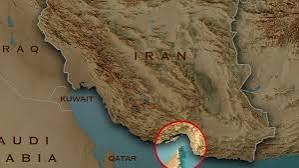
As the Gulf War enters its seventh month, it has become evident that all the horsing around is centred on the Strait of Hormuz.
The expression “horsing around” means “ to act in a silly, noisy, playful, or rough way instead of being serious.” But this is serious, no matter who the riders are.
United States President Donald Trump has declared the Strait “American territory”. He has issued a map.
This is not surprising considering he once declared Canada as “America’s 51st State”, actually controls Venezuela, wants to purchase Greenland, ‘take’ Cuba, and rechristen the Gulf of Mexico as the “Gulf of America.” The latest is declaring Canada’s Ontario Lake as “American Lake” and taking control of much of Venezuela’s oil. It is part of his global horse-trading.
Why are we focused on “horsing around” and “horse trading? Simply because, centuries before the map came, there was a horse. Remember ‘Ashwamedha” in ancient India?
Not merely a ‘yagna’, a religious ritual, it also had a political dimension. A consecrated horse was released to wander through neighbouring kingdoms, accompanied by the king’s warriors.
The horse could go where it pleased. A ruler whose territory it entered faced a choice: allow it to pass, and acknowledge the superior king’s claim, or stop the horse and challenge that claim.
Capture the horse and war could follow. It was, in effect, a mobile declaration of sovereignty.
Trump’s map also makes a political claim: this space is ours.
Iran has posted a satirical map that labels California as “new Iranian territory”. This dismissal is understandable. A presidential post on social media cannot, by itself, transfer sovereignty over a waterway lying far away, between Iran and Oman.
Yet this raises a larger and rather fascinating question. How did rulers assert territorial sovereignty before there were maps? That takes us unexpectedly into mythology.
There were no coloured lines on a map. No surveyors. No coordinates. No satellite imagery. A horse marked the limits of power.
Where the horse went unchallenged, sovereignty was acknowledged. Where somebody stopped it, this meant resistance.
The Ramayana gives us the famous Ashvamedha of Rama. The horse was tied by his exiled sons, Lav and Kush. The Mahabharata provides a fuller political picture. Arjun followed Yudhishthira’s Ashvamedha horse and confronted rulers who challenged its passage.
It is tempting to see in this an ancient version of international politics. But the analogy should not be stretched too far. The Ashvamedha, a ritual embedded in a particular religious and political culture, was not a modern-day doctrine of territorial annexation. Yet as a symbolic test of sovereignty, it was remarkably clear.
And here lies the curious connection with Hormuz. Trump has replaced the horse with the map. It declares: “This is American territory.” The difference is only technological: Its political instinct is ancient.
The epics of ancient Greece had their own language demanding submission. They offer less exact parallels to the Ashvamedha. But the underlying idea was to demand submission or war.
The Persian demand for “earth and water” from Greek states was another striking example. It represented submission to Persian authority.
Again, the claim preceded the conquest, on the same Imperial pattern: first comes the assertion; then the test; then recognition—or resistance.
Modern diplomacy has merely given the process more sophisticated vocabulary. Maps have become weapons.
China’s nine-dash line in the South China Sea is a contemporary example. Argentina’s maps showing the Falklands/Malvinas as Argentine territory are another. India and Pakistan have long published maps reflecting their competing claims over Jammu and Kashmir.
The map does not create sovereignty. But it tells the world a government’s claim.
Occasionally the map precedes reality. Where military power, administration, settlement or diplomacy subsequently reinforce the claim, yesterday’s disputed line can become tomorrow’s accepted boundary.
Where they do not, the map becomes a historical curiosity.
That is why Trump’s Hormuz map is more interesting than it first appears. Legally, drawing a line does not make the Strait of Hormuz American territory. Politically, however, it tells Iran, Oman and the Gulf monarchies something about the way Washington currently sees the region.
Trump’s map may be more unsettling to America’s friends. Iran can laugh at the map, but Oman cannot. Oman occupies the strategically vital Musandam Peninsula on the southern end of Hormuz. It is also among the few Gulf countries that have maintained unusually good relations with Iran while remaining an American security partner. Even an implied American claim over Hormuz can make Oman uncomfortable.
Saudi Arabia, the UAE, Qatar, Bahrain and Kuwait face a similar dilemma in different forms. They need American military power to deter Iran and protect their security. Yet they also have reasons to resist excessive demands from Washington.
For years, the Gulf monarchies have been diversifying their relationships—towards China, towards independent diplomacy with Iran and towards greater strategic autonomy.
Trump’s map declaring Hormuz American territory could unintentionally accelerate that process.
The irony is striking.
The Gulf Arabs who once feared that Iran might dominate the region invited the US to prevent precisely that. They may now have to fear another possibility: Iranian predominance replaced by American predominance.
The two are not equivalent, of course. But small and medium-sized states have always been wary of being caught between great powers.
Has the horse been stopped? Iran has. Hence Trump’s declaration through a map.
This brings us back to Ashvamedha.
The ancient king’s claim acquired legitimacy through acquiescence. If not, it had to be defended. Trump’s map faces this test.
But the map itself settles nothing, whatever colour Trump paints Hormuz with. Iran has rejected the claim. Oman can object. The Gulf states can remain silent or express concern. Others can invoke international law.
The real question is: Will the world accept the claim—or will somebody stop the horse?
Perhaps this makes the Hormuz episode more than just another Trumpian provocation.
For thousands of years, rulers have sought ways of saying: “This is mine.”
The medium has changed.
The ancient Indian king sent a horse.
The Persian king demanded earth and water.
Empires drew boundaries.
Modern states publish maps.
But beneath all these forms lies the same primitive question of power: Dare anyone challenge the claim?
The horse, unlike the map, had to move.
That is perhaps the oldest lesson in geopolitics: sovereignty is not established by what a ruler draws or declares. It is established by what others are prepared—or forced—to accept.
The Hormuz map has been drawn. Iran has, in effect, stopped the horse.
The world is still deciding whether to let the horse pass. (

Mahendra Ved is a veteran Journalist and an Expert on international affairs.